Carregar apresentação
A apresentação está carregando. Por favor, espere

1
GLOBIOM BRAZIL PRELIMINARY RESULTS Adriana Affonso Ricardo Cartaxo Cambridge,UK – June 10, 2013 National Institute for Space Research - Brazil

2
6 Biomes

3
Vegetation classes– IBGE (1992)
")
4
Biomes Original area (ha)* C stock in original biome (Pg C) *** % biome change 1994 to 2002* Liquid emissions (Pg CO 2 ) between 1940 and 1995** Liquid emission (Pg CO 2 ) between 1994 and 2002* Liquid emission (Pg CO 2 ) total between 1940 and 2002 Amazonia 419.763.07368,419,215,76±6,96,822,56±6,9 Cerrado203.953.33021,312,917,96±9,92,420,36±9,9 Pantanal15.131.0220,6570,88±0,470,121±0,47 Caatinga82.789.1396,59,70,77±0,440,301,07±0,44 Mata Atlântica111.789.93017,64127,13 ±150,6327,76±15 Pampa16.571.2971,31,8%0,44±0,25-0,00160,438±0,25 Source: *MCT, 2010b; **Confidence interval 90%, Leite et al. (2012). Brazilian Panel on Climate Change, 2013. Mitigating Climate Change: Contributions of the Working Group III to the First Report of the National Evaluation on Climate ChangeCOPPE. Universidade Federal do Rio de Janeiro, Rio de Janeiro, RJ, Brasil, 405 pp. ISBN: 978-85-285- 0207-7 BIOMES BIOMASS
. Brazilian Panel on Climate Change, Mitigating Climate Change: Contributions of the Working Group III to the First Report of the National Evaluation on Climate ChangeCOPPE. Universidade Federal do Rio de Janeiro, Rio de Janeiro, RJ, Brasil, 405 pp. ISBN: BIOMES BIOMASS.")
5
Not all forest typologies of Cerrado and Caatinga has all the requisites of forest definition. However, these ecosystem are used as forest- timber extraction, pulp, seed production, etc. So forest definition could include vegetation types that are not forest. FAO and Brazils National Forest Service consider some Cerrado and Caatinga physiognomies

6
Definition of Forest (FAO and NFS) Phytoecological regions Forest/.....
 Phytoecological regions Forest/.....")
7
Land Cover Land Use Available data CoverageSourcePeriodResolution BrazilGLC2000Tiff, 1km Amazonia (forest/non-forest) PRODES2000 and 201090m (Landsat) ProbioMMA/FUNCATE200230 m (Landsat) Probio deforestation Update IBAMA2002-2008 2008-2009 30 m (Landsat) PROVEGINPE-CPTEC20021 km (Landsat) Mta AtlânticaSOS201030 m (Landsat) CoverageSourcePeriodResolution BrazilIBGE Agri Censu2006Municipality BrazilINPE Agri Data2002-2003, 2010250m, AmazoniaTerraClass2008Shape, Tiff, 90m Centro-SulCanaSat2002, 2003Shape SP – Planted ForestIF2005Shape RS, SEIBGE Land Use2009, 2010Shape
 PRODES2000 and m (Landsat) ProbioMMA/FUNCATE m (Landsat) Probio deforestation Update IBAMA m (Landsat) PROVEGINPE-CPTEC20021 km (Landsat) Mta AtlânticaSOS m (Landsat) CoverageSourcePeriodResolution BrazilIBGE Agri Censu2006Municipality BrazilINPE Agri Data , m, AmazoniaTerraClass2008Shape, Tiff, 90m Centro-SulCanaSat2002, 2003Shape SP – Planted ForestIF2005Shape RS, SEIBGE Land Use2009, 2010Shape")
8
2000-2002 Forest Other Natural vegetation Grassland Not relevant Total agricultural land

9
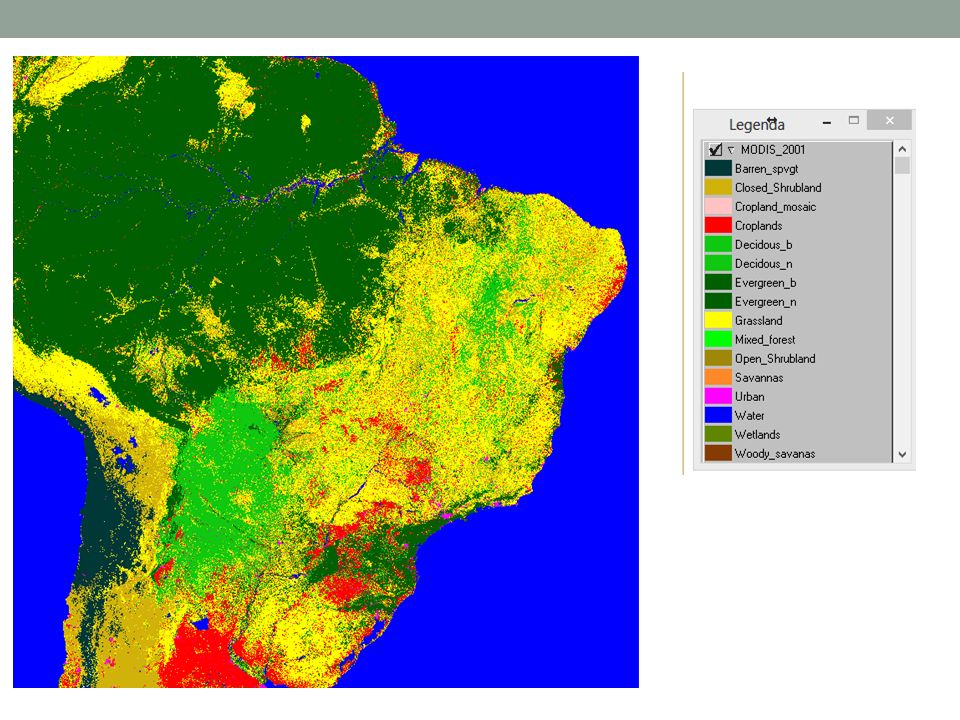
GLC

11
Forest Cerrado Grassland Caatinga Water Herbaceous PROVEG- 2000-2002 VIEIRA, R. M. S. P.; CARVALHO, V. C.; VALERIANO, D. M.; SESTINI, M. F.; SILVA, J. S. V. S.; ABDON, M. M.; PONZONI, F. J.; SANO, E. E.; HASENACK, H.; ALVALÁ, R. C. S.; FERRAZ-NETO, S. Mapa de uso e cobertura da terra do território brasileiro. São José dos Campos: INPE, 2010-01-27. (INPE ePrint sid.inpe.br/mtc-m19@80/2010/01.26.15.35). Disponível em:. Acesso em: 25 jun. 2013.

12
Issues Definition of classes Wetlands Planted forest

Apresentações semelhantes
: (based on and the message from INPAs General Director, Dr Adalberto Val, and on former.>")


