Carregar apresentação
A apresentação está carregando. Por favor, espere

1
Previsão Meteorológica Operacional: Modelos e Observações J.Delgado Domingos Prof.Cat.Instituto Superior Técnico Investigador IN+ Fundador e coordenador do Grupo de Previsão Numérica do Tempo (GPNT) Ciência 2010 Meteorologia, Previsão e Modelação 5-Julho-2010
 Ciência 2010 Meteorologia, Previsão e Modelação 5-Julho-2010")
2
“ voltar à ciência, aos problemas antigos por resolver, (...) às oportunidades económicas, à sociedade. (...) clarificar e debater, área a área, (...) fazer surgir as melhores ideias e as melhores lideranças, capazes de juntar pessoas, recursos e instituições, (...) investigação, indústria e ciência(...)” José Mariano Gago, MCTES Ciência 2010: Alguns OBJECTIVOS
 clarificar e debater, área a área, (...) fazer surgir as melhores ideias e as melhores lideranças, capazes de juntar pessoas, recursos e instituições, (...) investigação, indústria e ciência(...) José Mariano Gago, MCTES Ciência 2010: Alguns OBJECTIVOS.")
3
O GPNT surgiu em 1999 devido a ausência de respostas do Instituto de Meteorologia a solicitações da investigação e de actividades económicas e sociais no âmbito da Oceanografia, Poluição do Ar, Planeamento Biofísico, Energias Renováveis,etc. Beneficiou da experiência da Secção de Termodinâmica Aplicada do IST no desenvolvimento e aplicações de “CFD”(3d), Modelos de Turbulencia, etc iniciada nos anos 70 Grupo de Previsão Numérica do Tempo (GPNT): Antecedentes
, Modelos de Turbulencia, etc iniciada nos anos 70 Grupo de Previsão Numérica do Tempo (GPNT): Antecedentes.")
4
De entre as dezenas de modelos de área limitada a que teve acesso (USA,Europa, Canadá, Austrália) o GPNT optou pelo MM5, que implementou,em 1999, num cluster de PCs sem qualquer financiamento público explícito. Implemented also AWRF which become operational after 3 years testing. Utilizando o Modelo Global AVN (USA) para condições iniciais e fronteira, iniciou em 2001 a divulgação da previsão meteorológica para Portugal Continental (http:/meteo.ist.pt), com uma resolução espacial de 9x9 km. O GPNT foi o primeiro grupo a iniciar em Portugal, de modo operacional, a Previsão Numérica do Tempo e a disponbilizá-la publicamente. GPNT: Previsão Numérica do Tempo em Portugal com modelos de área limitada
 para condições iniciais e fronteira, iniciou em 2001 a divulgação da previsão meteorológica para Portugal Continental ( com uma resolução espacial de 9x9 km. O GPNT foi o primeiro grupo a iniciar em Portugal, de modo operacional, a Previsão Numérica do Tempo e a disponbilizá-la publicamente. GPNT: Previsão Numérica do Tempo em Portugal com modelos de área limitada.")
5
GPNT: Some Results 1.Wind Prediction 2.Portuguese Coast Forecast System 3.Lisbon-Urban Heat Island 4.Civil Protection 5.Extreme events (See http://meteo.ist.utl.pt and http://jddomingos.ist.utl.pt)http://meteo.ist.utl.pt

6
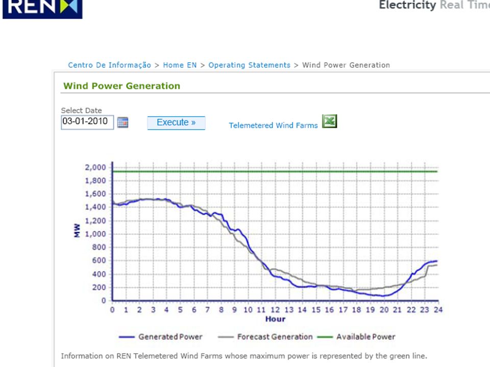
1.Wind Energy for the National Electric Grid (TSO) : After a demonstration period of ~1 year and 2 one semester contracts, GPNT suggested an international tender, including IM, INETI and Portuguese Universities. since 2005, after the international bid and benchmarking contract awarded to GPNT and U.Aveiro for 4x day wind forcast. GPNT achived 99.99% success rate (until now) with MM5 and WRF (9x9 and 3x3) for 92 wind farms. Prediction v. real time observation at : http://www.centrodeinformacao.ren.pt/EN/InformacaoExploracao/Pages/Diagram adeProduçãoEólica.aspx Wind Prediction
 with MM5 and WRF (9x9 and 3x3) for 92 wind farms. Prediction v. real time observation at : adeProduçãoEólica.aspx Wind Prediction.")
8
GPNT provides the meteorological input required by the Portuguese Coast Forecasting system run by the closely connect group Maretec who developed the model MOHID (http://www.mohid.com/ ) widely known, internationallyhttp://www.mohid.com/ Just some results of an international benchmarking of MOHID, using input from GPNT: Portuguese Coast forecasting
 widely known, internationallyhttp:// Just some results of an international benchmarking of MOHID, using input from GPNT: Portuguese Coast forecasting")
9
ECOOP Final Meeting – Istanbul – 22-24 March - 2010 Validation - Sea surface temperature MODIS L2 22 Feb 2009 PCOMS-MOHIDODYSSEA DIFFERENCE ODYSSEA minus PCOMS-MOHID MODIS L2PCOMS-MOHIDODYSSEAMODIS L2PCOMS-MOHID

10
ECOOP Final Meeting – Istanbul – 22-24 March - 2010 Validation – Surface buoys Puertos del Estado - Spain Instituto Hidrográfico - Portugal Sea surface temperature Surface currents, temperature and salinity

11
ECOOP Final Meeting – Istanbul – 22-24 March - 2010 Sea surface temperature Instituto Hidrografico Puertos del Estado

12
ECOOP Final Meeting – Istanbul – 22-24 March - 2010 Sea surface velocity & direction Puertos del Estado

13
ECOOP Final Meeting – Istanbul – 22-24 March - 2010 Validation - TOP

14
ECOOP Final Meeting – Istanbul – 22-24 March - 2010 Validation - TOP model observations

15
ECOOP Final Meeting – Istanbul – 22-24 March - 2010 Validation - TOP

16
ECOOP Final Meeting – Istanbul – 22-24 March - 2010 Validation – Argo floats CORIOLIS project (http://www.coriolis.eu.org)

17
ECOOP Final Meeting – Istanbul – 22-24 March - 2010 Oil Observer Online oil spill simulation tool

18
ECOOP Final Meeting – Istanbul – 22-24 March - 2010 SIGEL project Oil spill emergency management smart client

19
GPNT :2003 HEAT WAVE

20
GPNT participates on a ESA (European Space Agency) project on urban heat islands, as tester. To access the usefullness of presently available thermal imagery from LASAF at a pixel resolution of 3x3 km, GPNT simulated the Heat Wave of 2003 with MM5 and AWRF at 9x9, 3x3 and 1x1km spatial resolutions and several soil models Lisbon -Urban Heat Island

21
Ground Measuring Station

22
The Heat wave of 2003 Predicted and Measured temperatures at Lisbon Airport Urban Heat Island - Lisbon AWRF initialized with FNL (NCEP) 2 way nested (9km,3km, 1km)
 2 way nested (9km,3km, 1km)")
23
The Heat wave of 2003 Root Mean Square Error at Lisbon Airport Urban Heat Islands - Lisbon Summary 9km 3km 1km MAE 3.3753278 1.2163888 1.2858550 RMSE 4.3476656 1.5443446 1.6204324 SDE 2.7852428 1.5305532 1.5088376

24
Heat wave of 2003 00 hours August 1 Urban Heat Islands - Lisbon

25
Temperatures 2003-08-01:00

26
Urban Heat Island - Lisbon Black : T soil Green:T2m T2m –green Tskin -black

27
WRF Prediction vs LSASAF 2009-03-10:18h (3x3 km resolution) LSASAF 2009-03-10:18h (3x3 km resolution)
 LSASAF :18h (3x3 km resolution)")
28
Prediction 2009-03-10:18h (3x3 km resolution)
")
29
Lisbon Skin Temperature predicted (WRF) and satelite (LSASAF) (3x3 km resolution) from 2009-06-14 to 2009-06-21 LSASAF 2009-03-10:18h (3x3 km resolution)
 and satelite (LSASAF) (3x3 km resolution) from to LSASAF :18h (3x3 km resolution)")
30
Lisbon Civil Protection LSASAF 2009-03-10:18h (3x3 km resolution) Lisbon Civil Protection receives daily a weather forecast for 7 days, updated every 6 hours, based on MM5 (9x9 km) and WRF (3x3 km) with a visual indication of oficial (IM) alarm levels. For ex. At 6 am July 3, this one refers to air temperature at 2m

31
Extreme Events –basic considerations LSASAF 2009-03-10:18h (3x3 km resolution) Predicting extreme events originated in small scale features requires limited area models with a spatial resolution of, at least, 3 grid points inside the characteristic scale. MM5 and WRF models have these operational capabilities. To be useful for Civil Protection the models must be run in Operational Mode coupled with an automatic alert system as, for example, the currently used by GPNT. Currently available computational resources do not allow a meaningful probabilistic ensemble forecast model to be run operationally at the required spatial resolution.

32
Extreme Events & GPNT LSASAF 2009-03-10:18h (3x3 km resolution) To circunvent the operational limitations of conventional probabilistic ensemble forecasts, GPNT introduced operationally a time-lagged ensemble methodology, using daily a 168 hours(7 days) forecast based on 00h analysis, followed by 3 updated forecasts based on the analysis of 06h, 12h and 18h. The methodology as proved quite successful at Lisbon Civil Protection since its introduction in 2008, and for Wind Power prediction at REN.

33
The Extreme Rain Event in Madeira on Feb 20,2010 & GPNT LSASAF 2009-03-10:18h (3x3 km resolution) IM-Instituto de Meteorologia made an official statement saying it would be impossible to predict the event with reasonable anticipation without the Meteorological Radar they were requesting for a long time. IM also stated to be impossible an internal preparedness warning 7 days before, and a public red warning 48h before. GPTN made public that its operational warning system, already tested at Lisboa Civil Protection, would have made an internal preparedness warning 7 days before, and would have recommendd a public red warning 48h before. GPNT also discarded the usefulness of a Meteorological Radar for the early prediction of this particular extreme event. It could even lead to a wrong evaluation On June 30, 2010, the University of Évora convened the Portuguese Groups who do research and NWP to present their views in an open public discussion. Our presentation is already publicly available at GPNT site (http://meteo.ist.utl.pt )tp://meteo.ist.utl.pt NO one endorsed the official statements of IM NO one questioned the scientific foundation of my public statements
tp://meteo.ist.utl.pt NO one endorsed the official statements of IM NO one questioned the scientific foundation of my public statements.")
34
Location of IM Meteo Stations EstaçãoLat (N) Lon (O) Areeiro32°43’16°55’ Funchal/Ob32°38’16°53’ http://www.meteo.pt/pt/enciclopedi a/redes/redes.meteo/index.html IM gives coordinates rounded to minits(‘). Areeiro is near another station with the same name from another organization (IGA) which rounds to seconds(‘’). The coordinates given by IM to Funchal/Observatório puting it in the sea so we took the location of the adress of Observatório.
 which rounds to seconds(‘’). The coordinates given by IM to Funchal/Observatório puting it in the sea so we took the location of the adress of Observatório..")
35
15_00_3km 16_00_3km 17_18_3km 18_00_3km 18_00_1km 18_06_3km 18_12_3km 18_18_3km 40 ALL forecasts above the red alert GPNT: Time lagged Ensemble forecasts & obs

36
Data according to IM and IGA at Areeiro

37
IM: Boletim Climatológico Fev 2010 Segundo o gráfico é 2 horas depois das 9:00 e uma hora antes das 12:00, ou seja 11:00, ou 09:50/10:50.

38
Boletim Climatológico Fev 2010 Segundo o gráfico o - Máx (1hora) < 70 mm e não 78.5. - Máx (1hora) ocorre depois das 12:00 e não às 08:50/09:50.
 ocorre depois das 12:00 e não às 08:50/09:50..")
39
SOME CONCLUSIONS

40
Scientific Remarks :Models MM5 and WRF are state of the art models. They became a reference at international level. WRF benefited from the experience accumulated with MM5 and expanded remarkably its flexibility and user friendliness. Its dynamic user base and the individual and institutional contributors improves WRF with each yearly updated release. WRF_3.2 (2010) is now a robust and reliable system. GPNT was one of the testers before official release. Accessing the reliability and quality of a Model is a very long, complex and time consuming task. Using it in real time operational mode is not trivial and requires experience. There are other very good, state of the art models, namely in Europe. For specific research needs, they are clearly useful. However, for operational use, a full change from one model to another is always difficult to justify on a risk/benefit analysis
 is now a robust and reliable system. GPNT was one of the testers before official release. Accessing the reliability and quality of a Model is a very long, complex and time consuming task. Using it in real time operational mode is not trivial and requires experience. There are other very good, state of the art models, namely in Europe. For specific research needs, they are clearly useful. However, for operational use, a full change from one model to another is always difficult to justify on a risk/benefit analysis.")
41
Scientific Remarks :DATA The real Physical World do not read papers, or know about models. Models are always a simplified representation of what humans assume to be the Physical World. To be a physical model (not a science fiction fantasy), its predictions must be compared with reliable and careful measurements. Reliable and careful measurements of meteorological variables are so important that taxpayers accept the considerable expenditure needed to get them. They even give unique legal rights to an institution on charge of it, which in Portugal is the Instituto de Meteorologia. Meteorological data is a public good, and is paid by taxpayers because it is supposed to be so. In Portugal (like in some other countries, but not in USA …) Instituto de Meteorologia considers the data it collects with public money as private property to be sold or given at its only discretion. In the real human world, this attitude is the shortest way for a complete loss of scientific accountability.
, its predictions must be compared with reliable and careful measurements. Reliable and careful measurements of meteorological variables are so important that taxpayers accept the considerable expenditure needed to get them. They even give unique legal rights to an institution on charge of it, which in Portugal is the Instituto de Meteorologia. Meteorological data is a public good, and is paid by taxpayers because it is supposed to be so. In Portugal (like in some other countries, but not in USA …) Instituto de Meteorologia considers the data it collects with public money as private property to be sold or given at its only discretion. In the real human world, this attitude is the shortest way for a complete loss of scientific accountability..")
42
Scientific and Institutional Accountability Whatever the model or Institution’s statements, its correctness or usefulness can only be reasonably accessed comparing its predictions and statements with careful and reliable measurements. Otherwise, we are confusing a system of believes with Science. To be credible and accepted, all the testing data must be freely available, as is becoming widely and officially recognized, (thanks do Climate Gate ?). In Portugal, Instituto de Meteorologia practically refuses, when it bothers to answer, all requests of data, being it real or historical time series. Lack of accountability leads directly to loss of data quality and reliability. The sloppiness already shown for Madeira is just a reminder.
. In Portugal, Instituto de Meteorologia practically refuses, when it bothers to answer, all requests of data, being it real or historical time series. Lack of accountability leads directly to loss of data quality and reliability. The sloppiness already shown for Madeira is just a reminder..")
43
“ voltar à ciência, aos problemas antigos por resolver, (...) às oportunidades económicas, à sociedade” 1.O acesso livre e gratuito aos dados refere-se aos dados em bruto, não a dados com valor acrescentado. Este suposto valor acrescentado pode facilmente transformar-se numa perigosa “data massage”. 2.O IM afirma sempre que disponibiliza os dados para trabalhos de investigação, a custo do suporte. Não é isto que sucede com grande frequencia. O mais comum é nem sequer responder ao pedido. Quando responde é a pedir um custo exorbitante (…pelo suporte ?). 3.O IM interpreta a prestação de serviços à comunidade feita pelas Universidades e seus Centros de Investigação como “ venda de serviços à pala da investigação (sic)”. Sendo todos estes organismos tutelados pelo mesmo Ministério que estimula, e bem, a prestação de serviços e a obtenção de receitas pelas Universidades e Centros de Invstigação, que fundamento ético ou legal invoca o IM para o seu modo de proceder?
. 3.O IM interpreta a prestação de serviços à comunidade feita pelas Universidades e seus Centros de Investigação como venda de serviços à pala da investigação (sic) . Sendo todos estes organismos tutelados pelo mesmo Ministério que estimula, e bem, a prestação de serviços e a obtenção de receitas pelas Universidades e Centros de Invstigação, que fundamento ético ou legal invoca o IM para o seu modo de proceder .")
44
“ voltar à ciência, aos problemas antigos por resolver, (...) às oportunidades económicas, à sociedade” 5. Pelo modo como o IM divulga as suas receitas próprias, tenho as maiores dúvidas que as receitas provenientes da venda de dados em bruto tenham valor significativo. É muito mais plausivel que se trate de um pretexto para escamotear a falta de qualidade e de fiabilidade que um escrutínio sério poria em eviencia. 6.Integrado num Ministério da Ciência é paradoxal que o IM não permita acesso aos dados e algoritmos em que baseia as suas estrondosas afirmações sobre as alterações climáticas que se teriam verificado ou irão verificar em Portugal. Dadas as importantíssimas implicações sociais e económicas das decisões de politica nacional nesta matéria, poderá o Ministério aceitar que as “verdades convenientes do IM” se transformem em verdades científicas, acima de qualquer dúvida ou escrutinio ?. Não só não pode como certamente o não fará 6. O GPNT nasceu e existe, de modo totalmente independente do IM e totalmente financiado pela indústria (porque o seu trabalho tem valor económico), mas é e sempre foi UNIVERSITÁRIO.
, mas é e sempre foi UNIVERSITÁRIO..")
45
“ voltar à ciência,, (...) às oportunidades económicas, à sociedade” OBRIGADO PELA ATENÇÃO …
 às oportunidades económicas, à sociedade OBRIGADO PELA ATENÇÃO …")
Apresentações semelhantes


>")


 Canta: Gladys Knight (H. Bergman/M.Bergman/M. Hamlisch)>")


