Carregar apresentação
A apresentação está carregando. Por favor, espere

1
ANA - Agência Nacional de Águas
Sistema Nacional de Informações sobre Recursos Hídricos ANA - Agência Nacional de Águas SGI – Superintendência de Gestão da Informação Maurício Cezar Rebello Cordeiro 29/Jun/2009

2
Objetivos do SNIRH (Lei 9433/97)
Reunir, dar consistência e divulgar os dados e informações sobre a situação qualitativa e quantitativa dos recursos hídricos no Brasil Atualizar permanentemente informações sobre disponibilidade e demanda de recursos hídricos Fornecer subsídios para elaboração de Planos de Recursos Hídricos Lei 9984/00 – art. 4º, inc. XIV organizar, implantar e gerir o Sistema Nacional de Informações sobre Recursos Hídricos;

3
Recursos Humanos e Organizacionais Infra-estrutura Computacional
Usuários Intervenientes Suporte e Atendimento Capacitação Órgãos Intervenientes Servidores Estações de Trabalho Recursos de Comunicação Software Básico e de Sistema Base de dados Protocolo de Integração Barramento de Serviços Interface SNIRH Subsistema Sistemas Internos/Externos Sistema Plataforma de Integração Águas Superficiais Águas Subterrâneas Complementos Hidrologia Planejamento e Gestão Inteligência Hídrica Regulação de Usos Inteligência Geográfica Rede Hidrológica Inteligência Documental Elementos de Suporte (segurança, metadados, ...)
")
4
MDSA PDTI

5
Implantação da Infra-estrutura

6
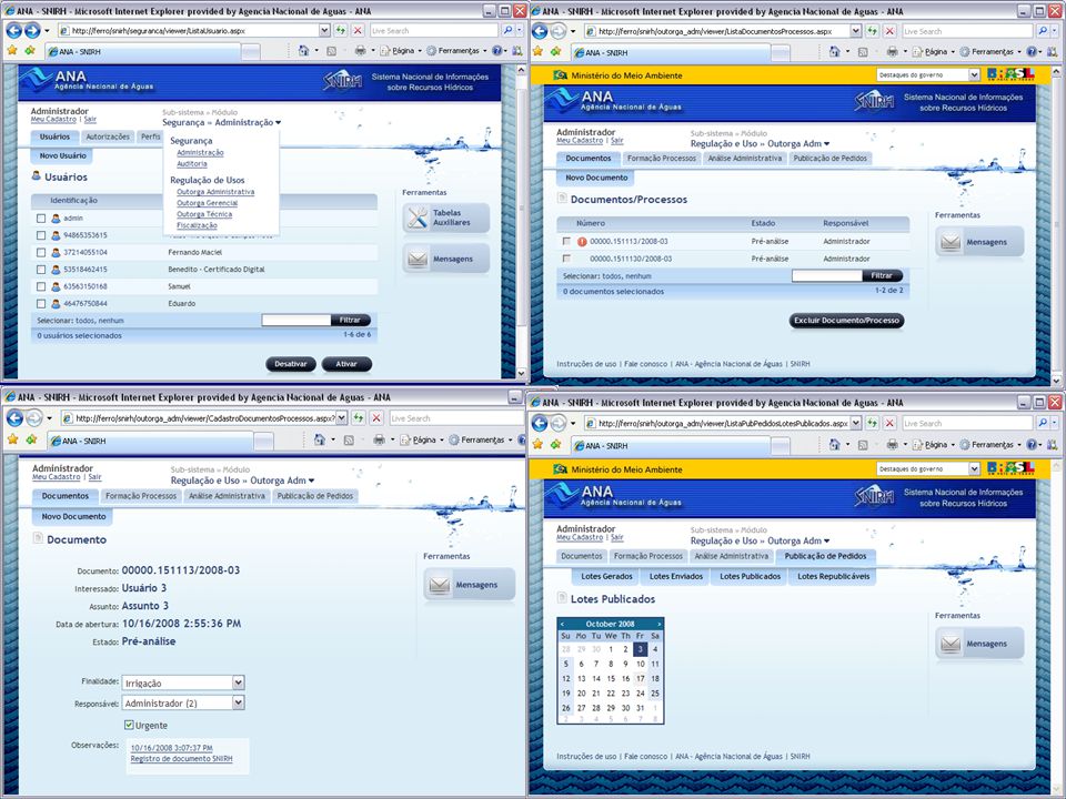
SUBSISTEMA: REGULAÇÃO DE USOS
Reúne informações sobre usos de recursos hídricos em todo o território nacional Visa possibilitar a regulação do uso dos recursos hídricos em bacias com dominialidade repartidas entre União e Estados Processos associados: Cadastro de Usuários (CNARH) Outorga de uso em corpos hídricos Cobrança de usos em corpos hídricos Fiscalização de usos em corpos hídricos de domínio da União Recebimento e disponibilização aos gestores estaduais de dados de usuários e maneira a permitir a coerência no exercício da regulação dos usos
 Outorga de uso em corpos hídricos. Cobrança de usos em corpos hídricos. Fiscalização de usos em corpos hídricos de domínio da União. Recebimento e disponibilização aos gestores estaduais de dados de usuários e maneira a permitir a coerência no exercício da regulação dos usos.")
7
Base Corporativa Subsistema Regulação de Usos Segurança
Cadastro Cobrança Gestão de Recursos Fiscalização Segurança Cadastro de Usuários Cadastro de Usuários Cadastro de Poços Planejamento Arrecadação de Recursos Demandas e Denúncias Declaração de Uso Cadastro de Registros Ficha de Cobrança Administração Financeira Planejamento de Campanhas Outorga Ajuste de Uso Aplicação de Recursos Execução de Campanhas Pré-Análise Auto de Infração Gestão de Outorga Controle de Processos Suporte à Decisão Formalização Declaração de Reserva de Disponibilidade Hídrica (DRDH) Base Corporativa Declarações e Certificados Gestão de Condicionantes Certificado de Sustentabilidade da Obra Hídrica(CERTOH) Inteligência Geográfica Interface de Integração 7
 Base Corporativa. Declarações e. Certificados. Gestão de Condicionantes. Certificado de Sustentabilidade da Obra Hídrica(CERTOH) Inteligência Geográfica. Interface de Integração. 7.")
8
As coordenadas informadas
SUBSISTEMA: REGULAÇÃO DE USOS Cadastro - Interface Geográfica As coordenadas informadas não correspondem ao rio selecionado RIO CAMANDUCAIA FEDERAL

9
SUBSISTEMA: REGULAÇÃO DE USOS
Cadastro - Consultas gerenciais

10
SUBSISTEMA: REGULAÇÃO DE USOS
Módulo de Cobrança

11
Atualmente, o CNARH atende as seguintes bacias/estados:
• São Francisco (ajustes para a simulação da cobrança) • PCJ e Paraíba do Sul; MG – o Igam vai adotar o CNARH para cobrança no rio das velhas, PCJ e Paranaiba (2009); • Doce, Preto, Piranhas-Açu, Verde Grande; Rio de Janeiro - adotou integralmente o CNARH como sistema de cadastro; estadual e também o módulo de cobrança. Além do Rio, CE, MS e RS consideram também a adoção CNARH.
 • PCJ e Paraíba do Sul; MG – o Igam vai adotar o CNARH para cobrança no rio das velhas, PCJ e Paranaiba (2009); • Doce, Preto, Piranhas-Açu, Verde Grande; Rio de Janeiro - adotou integralmente o CNARH como sistema de cadastro; estadual e também o módulo de cobrança. Além do Rio, CE, MS e RS consideram também a adoção CNARH.")
13
Cenário 1: Estado Utiliza o CNARH
Atualiza Dados de Cadastro do Estado no CNARH Ambiente ANA Ambiente Estado Internet Aplicativo Base CNARH Web Service Expõe CNARH ODBC Internet Web Service Aplicativo gera Declaração Retificadora Sistemas Estaduais (ex. Outorga) Grava Declaração Retificadora/Nova Web Service Grava Declaração Retificadora Recebe Declaração Retificadora ou uma nova declaração (no caso de garga inicial)e grava no CNARH Aplicativo gera Declaração Retificadora Aplicativo feito pelo Estado que gera Declaração retificadora e chama Web Service Retificador (Dependente da estrutura do banco) 13
 Grava Declaração Retificadora/Nova. Web Service Grava Declaração Retificadora. Recebe Declaração Retificadora ou uma nova declaração (no caso de garga inicial)e grava no CNARH. Aplicativo gera Declaração. Retificadora. Aplicativo feito pelo Estado que gera Declaração retificadora e chama Web Service Retificador. (Dependente da estrutura do banco) 13.")
14
Compartilhados com base no CNARH Compartilhados do Estado
Cenário 2: Grava os Dados de Cadastro Compartilhado com base no CNARH e nos Cadastros Estaduais Ambiente ANA Ambiente Estado Web Service Mostra Dados Compartilhados com base no CNARH Web Service Mostra Dados Compartilhados do Estado Web Service que fornece os campos necessários ao Cadastro Compartilhado com base no CNARH Web Service feito pelo Estado que fornece os campos necessários ao Cadastro Compartilhado com base no Cadastro Estadual (Dependente da estrutura do banco) Internet Web Service que fornece os campos necessários ao Cadastro Compartilhado com base no CC na ANA Web Service Mostra Dados Compartilhados com base no CC ODBC Aplicativo Carrega CC Aplicativo Carrega CC grava o Cadastro Compartilhado lendo os WebServices de dados compartlhados ODBC Aplicativo Carrega CC
 Internet. Web Service que. fornece os campos necessários ao Cadastro Compartilhado com base no CC na ANA. Web Service. Mostra Dados. Compartilhados com base no CC. ODBC. Aplicativo Carrega CC. Aplicativo Carrega CC grava o Cadastro Compartilhado lendo os WebServices de dados compartlhados. ODBC. Aplicativo Carrega CC.")
15
Subsistema de Inteligência Geográfica
1) Baseado na codificação de Otto Pfafstetter para bacias hidrográficas. The codes store topological hydrograph information (montante e jusante) 2) Hidrografia é dividida em trechos de rios 3) É gerada a área de contribuição para cada trecho de rio 7721 7723 7725 This is a very important subsystem as it serve as a core to the whole system. This subsystem is based upon the ottopfafstetter coding for river basins that holds on the code the topological information of the hydrographic network. (melhorar o slide…mostrar um trecho de hidrografia e associando um ponto) Only by using this coding we estabilishes conectivity among the estretches After all the points are referenced to a stretch, we can store all the information we want, even geographical information such as land use or population on a tabular database. Through the ottopfafstetter coding, we can access all the stretches downstream and upstream a given point only with a tabular query. So we can make queries like, who are the users upstream this point?, or what is the total amount of withdrawals upstream?, or even What is the drainage area and land use of this basin? Without the need of a geographic processing, that are always too slow to be done over the internet. This is a very important subsystem as it serve as a core to the whole system. This subsystem is based upon the ottopfafstetter coding for river basins that holds on the code the topological information of the hydrographic network. (melhorar o slide…mostrar um trecho de hidrografia e associando um ponto) By this process we link each point of interest to a stretch of the river. These points of interest can be water users, stations, reservoir, etc. After all the points are referenced to a stretch, we can store all the information we want, even geographical information such as land use or population on a tabular database. Through the ottopfafstetter coding, we can access all the stretches downstream and upstream a given point only with a tabular query. So we can make queries like, who are the users upstream this point?, or what is the total amount of withdrawals upstream?, or even What is the drainage area and land use of this basin? Without the need of a geographic processing, that are always too slow to be done over the internet. 7727
 Baseado na codificação de Otto Pfafstetter para bacias hidrográficas. The codes store topological hydrograph information (montante e jusante) 2) Hidrografia é dividida em trechos de rios. 3) É gerada a área de contribuição para cada trecho de rio This is a very important subsystem as it serve as a core to the whole system. This subsystem is based upon the ottopfafstetter coding for river basins that holds on the code the topological information of the hydrographic network. (melhorar o slide…mostrar um trecho de hidrografia e associando um ponto) Only by using this coding we estabilishes conectivity among the estretches. After all the points are referenced to a stretch, we can store all the information we want, even geographical information such as land use or population on a tabular database. Through the ottopfafstetter coding, we can access all the stretches downstream and upstream a given point only with a tabular query. So we can make queries like, who are the users upstream this point , or what is the total amount of withdrawals upstream , or even What is the drainage area and land use of this basin Without the need of a geographic processing, that are always too slow to be done over the internet. This is a very important subsystem as it serve as a core to the whole system. This subsystem is based upon the ottopfafstetter coding for river basins that holds on the code the topological information of the hydrographic network. (melhorar o slide…mostrar um trecho de hidrografia e associando um ponto) By this process we link each point of interest to a stretch of the river. These points of interest can be water users, stations, reservoir, etc. After all the points are referenced to a stretch, we can store all the information we want, even geographical information such as land use or population on a tabular database. Through the ottopfafstetter coding, we can access all the stretches downstream and upstream a given point only with a tabular query. So we can make queries like, who are the users upstream this point , or what is the total amount of withdrawals upstream , or even What is the drainage area and land use of this basin Without the need of a geographic processing, that are always too slow to be done over the internet")
16
Subsistema de Inteligência Geográfica
Usuários de Água Camadas Geográficas Estações This is a very important subsystem as it serve as a core to the whole system. This subsystem is based upon the ottopfafstetter coding for river basins that holds on the code the topological information of the hydrographic network. (melhorar o slide…mostrar um trecho de hidrografia e associando um ponto) By this process we link each point of interest to a stretch of the river. These points of interest can be water users, stations, reservoir, etc. After all the points are referenced to a stretch, we can store all the information we want, even geographical information such as land use or population on a tabular database. Through the ottopfafstetter coding, we can access all the stretches downstream and upstream a given point only with a tabular query. So we can make queries like, who are the users upstream this point?, or what is the total amount of withdrawals upstream?, or even What is the drainage area and land use of this basin? Without the need of a geographic processing, that are always too slow to be done over the internet. This is a very important subsystem as it serve as a core to the whole system. This subsystem is based upon the ottopfafstetter coding for river basins that holds on the code the topological information of the hydrographic network. (melhorar o slide…mostrar um trecho de hidrografia e associando um ponto) By this process we link each point of interest to a stretch of the river. These points of interest can be water users, stations, reservoir, etc. After all the points are referenced to a stretch, we can store all the information we want, even geographical information such as land use or population on a tabular database. Through the ottopfafstetter coding, we can access all the stretches downstream and upstream a given point only with a tabular query. So we can make queries like, who are the users upstream this point?, or what is the total amount of withdrawals upstream?, or even What is the drainage area and land use of this basin? Without the need of a geographic processing, that are always too slow to be done over the internet. População Uso do solo Vegetação Geologia ... Reservatórios
 By this process we link each point of interest to a stretch of the river. These points of interest can be water users, stations, reservoir, etc. After all the points are referenced to a stretch, we can store all the information we want, even geographical information such as land use or population on a tabular database. Through the ottopfafstetter coding, we can access all the stretches downstream and upstream a given point only with a tabular query. So we can make queries like, who are the users upstream this point , or what is the total amount of withdrawals upstream , or even What is the drainage area and land use of this basin Without the need of a geographic processing, that are always too slow to be done over the internet. This is a very important subsystem as it serve as a core to the whole system. This subsystem is based upon the ottopfafstetter coding for river basins that holds on the code the topological information of the hydrographic network. (melhorar o slide…mostrar um trecho de hidrografia e associando um ponto) By this process we link each point of interest to a stretch of the river. These points of interest can be water users, stations, reservoir, etc. After all the points are referenced to a stretch, we can store all the information we want, even geographical information such as land use or population on a tabular database. Through the ottopfafstetter coding, we can access all the stretches downstream and upstream a given point only with a tabular query. So we can make queries like, who are the users upstream this point , or what is the total amount of withdrawals upstream , or even What is the drainage area and land use of this basin Without the need of a geographic processing, that are always too slow to be done over the internet. População. Uso do solo. Vegetação. Geologia. ... Reservatórios.")
17
Quem são os usuários a montante de um ponto de interesse?
Todas essas questões são respondidas por consultas tabulares em banco de dados Quem são os usuários a montante de um ponto de interesse? Qual a população e a área de drenagem a montante de qualquer trecho de rio? Quais estações estão a jusante de uma determinada cidade? This is a very important subsystem as it serve as a core to the whole system. This subsystem is based upon the ottopfafstetter coding for river basins that holds on the code the topological information of the hydrographic network. (melhorar o slide…mostrar um trecho de hidrografia e associando um ponto) By this process we link each point of interest to a stretch of the river. These points of interest can be water users, stations, reservoir, etc. After all the points are referenced to a stretch, we can store all the information we want, even geographical information such as land use or population on a tabular database. Through the ottopfafstetter coding, we can access all the stretches downstream and upstream a given point only with a tabular query. So we can make queries like, who are the users upstream this point?, or what is the total amount of withdrawals upstream?, or even What is the drainage area and land use of this basin? Without the need of a geographic processing, that are always too slow to be done over the internet.
 By this process we link each point of interest to a stretch of the river. These points of interest can be water users, stations, reservoir, etc. After all the points are referenced to a stretch, we can store all the information we want, even geographical information such as land use or population on a tabular database. Through the ottopfafstetter coding, we can access all the stretches downstream and upstream a given point only with a tabular query. So we can make queries like, who are the users upstream this point , or what is the total amount of withdrawals upstream , or even What is the drainage area and land use of this basin Without the need of a geographic processing, that are always too slow to be done over the internet.")
18
Portal SNIRH – Publicação de Informações
Publicação de Informações na internet através do link

19
Subsistema de dados quali-quantitativos
19

20
ANA - Agência Nacional de Águas SGI – Superintendência de Gestão da Informação Maurício Cezar Rebello Cordeiro (61)
")
Apresentações semelhantes